One day, back in late June or early July, not long after Colin’s bypass op, we took a circular drive, along the A66, turning off near Barnard Castle, to drive through the Stang Forest – or “over Stang” as we used to say when I lived down in the Dales. It was a climb up to the summit with a few sharp bends on the steepest part, and then a gradual run downhill, over Eskeleth Bridge, to meet the road coming from Reeth up Arkengarthdale. Just at the junction of the two roads you can see remains of what was a lead smelting mill. It has pretty well disappeared now but there are quite a number of buildings still standing in the area that had connections with the mill. For several generations in the 17th and 18th centuries the mill belonged to the Bathurst family and the ingots of lead they produced were marked CB for the first Bathurst - Charles. So now there is a group of houses called CB Yards, and down the road a bit is the CB Inn.
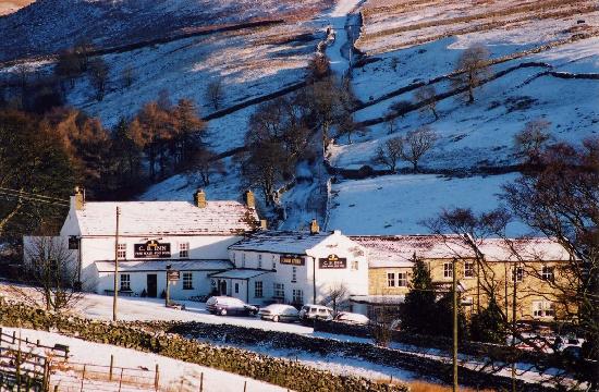
This photo of
The Cb Inn (Charles Bathurst Inn) is courtesy of TripAdvisor
I used to work at the CB (Inn) about 30-plus years ago. In fact it’s where I met Colin! It has all changed now though – quite different to the inn I remember!
Anyway we didn’t go down past the CB. Instead we turned up the dale and continued out past the village of Whaw, and various farms where once the lead mines had been, till eventually in the  middle of nowhere we arrived at Tan Hill Inn – the highest inn in the country. It’s a very popular , especially at weekends. We didn’t go in, but turned off on a narrow twisty road to the upper reaches of Swaledale - the valley of the river Swale.
Turning right would take us in the direction of Kirby Stephen, while left was to take us down dale and past some of my old stomping ground! It’s a lovely valley.
This is a typical dales view: long flat topped hillside covered in patchwork quilt of small fields separated by stone walls. Stone barns alongside the fields and small solid stone villages in the valley bottom. This is just above Keld.

We came into Muker (MEWker) and decided to stop at the tea shop advertised by its kettle, swinging from a metal wall bracket, as much as by the sandwich boards outside. I was once, over 30 years ago, an extra in a film called Evil under the sun, by Agatha Christie. Some of the filming took place here. In fact the building with the white door, in front of the church tower, normally the village hall ( I have danced the night away in that hall before now), was used as the local police station that Jane Birkin ran into, to report to the police that there was a dead body on the moors (that was me!).
After tea and a scone and jam, we continued on our way with many reminiscences from me of my time in the area all those years ago (though it only seems like a few years since I was there). So saying, I couldn’t remember where to find the house of a former boyfriend in Gunnerside.
 However through Low Row, we came to the village where I used to live – Healaugh, pronounced HEE law or locally HEE la with the a really sounding more like an er, without the r! There have been a few changes there, with new houses in converted barns, and old houses renovated. One thing I remember well was the telephone box – or kiosk – which was always looked after by one elderly lady of the village. It was lovely to see the kiosk still sporting a little pot of fresh flowers, as it did in Mrs N’s day. People using the phone here used to write little notes of thanks and admiration, sometimes leaving an odd coin or two which Mrs N donated to charity. The difference is that there is now a notice thanking people for their contributions and stating that the money is divided amongst the charities supported by the present villagers.
A mile further on is the largest village in the dale, Reeth, but before we descended the hill into the village, we stopped outside the primary school – these school kids must be fit with having to climb up that hill every day – to look over the wall at where the river Swale has over the years changed its course!  Here’s Colin looking like an old farmer leaning on the wall surveying the scene! This is what he was looking at…
The river used to meander in wide bends, gradually eroding the banks, and each winter, the rain and storms slightly changing its route over this flat flood plain. The last time I saw this view the river had torn through the countryside, leaving it looking like the remains of an old quarry, with the stones from the riverbed piled up on each other like the bed of some long dried up lake. The river didn’t even seem to know just where its bed was! However now it seems that the bends have gone, and the river now flows through in a straight course, leaving small ox bow lakes at least on one side. Grass is now growing over the piles of stones and at last it is looking like a more gentle scene again. It may take a few more years to settle, and no doubt the area will still flood at this point after a storm or two, but now that the river is flowing in “the shortest route between two points” it will probably continue in that way, and will never look like such a scene of devastation again.
Reeth has grown! Loads of new houses have been built around the edges of the village I remember. Part of the village green bordering the road at the top of the village – the Cobbles, colloquially - has been turned into hard-standing for the many cars parked by visitors – like us! We had a quick walk round the village - more reminiscences – but were soon on our way again as we had a visit with some friends of Colin’s in Richmond, some ten miles down the road.  They live right down beside the river, still the Swale, near the 18th century bridge that was built by two different builders.

When it came to the parapet, the builder on the Richmond side of the river used three rows of stone blocks, while the builder on the other side used two rows of larger stone blocks to achieve the same height. Obviously there had been little communication between the two.
We spent a very pleasant time with M and R, but soon it was time to head home. Just one last picture! A wild geranium was a delightful splash of blue amongst the green along the riverside below the old bridge which you might make out in the background.
Talk again soon.
PS The photo of Reeth with a still meandering river in the foreground was taken from this website. The rest are my own.


